Created by
Jo Rudnitski,
New York Mills High School
Targeted Level-Middle School-Gr. 7/8
Estimated time needed: three class periods plus two homework/extension activities.
Subject: US History-Pre-history through 1607
Standards: Minnesota Academic Standards-US History Middle School Standard I-Sub-strand B: 1.The student will identify key European explorers and how their voyages led to the establishment of colonies. 2. Students will know and explain that interactions between American Indian Tribes and the European explorers had positive and negative impacts.
National Standards-Chronological thinking, historical comprehension, and historical research
Task: Using maps, web sites, textbooks, reference books and handouts, the students will demonstrate an understanding of the contributions and claims of European explorers in the New World and the resulting interaction with the Native Americans during the exploration of the North American continent.
Background knowledge needed: Students should have an understanding of the Native American cultural regions of the North American continent before exploration to help them understand the causes and effects of exploration and settlement. (MN Academic Standards-US History Stand I-Sub-strand A). I’ve included a blank map to aid in the review of knowledge about the cultural areas and for use in comparison to the lands claimed by European countries during exploration. The blank map can be found in the file of materials for this lesson.
The People of North America
Based on lesson plans in Mission to America: A Teacher’s Guide to Historical Background and Lesson Plans-A Colonial Williamsburg publication-copyright 2000.
Other resources needed:
*Student textbook or reference books outlining key explorers, sponsoring countries, their motives, and their achievements in exploration of the New World; and an understanding of the Columbian Exchange.
*Possible websites for further information about maps, primary documents, and information about explorers-when, where and achievements:
http://nationalhumanitiescenter.org/pds/amerbegin/exploration/exploration.html
http://history.howstuffworks.com/north-american-history/famous-north-american-explorers.htm?page=1
*“Mapping Colonial America” (CD-ROM) The Colonial Williamsburg Foundation- students should explore the maps and focus on the detail and accompanying images. For comparison, the present-day map comparison feature is quite interesting.
*The Light in the Forest by Conrad Richter (novel). This novel provides a fictional account of a White child, Johnny Butler, who was captured by Lenni Lenape Indians when he was four and was raised by one of the warriors as a son. At age fifteen, True Son, his Lenni Lenape family name, is returned to his White family as a result of a treaty. The novel gives a good comparison of views each group has about the other, and the conflict John experiences. Chapter 5 and 6 prove a good comparison of True Son’s view of the land versus Del Hardy, a soldier, view of leaving the forest and approaching White settlements and Fort Pitt. (RL- Gr. 4)
*colored pencils and supplies for student summary projects
Activity One:
Timeline Activity
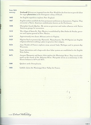
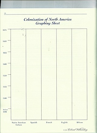
Using the Timeline of Events from the Mission to America publication (provided in this lesson), textbooks, websites, and reference materials, students will use the information to complete a Colonization of North America Graphing Sheet (included from the Mission to America publication) to complete a line graph (found in file with the lesson). Working in groups, the students should refer to the timeline, websites, textbook, etc, and will place a dot in the corresponding date in the column for each of the groups mentioned in the timeline-Spain, France, English, and Native Americans. Once their graph is completed, the students should generate at least five conclusions they have reached from their review of information displayed in their graph. These conclusions should be listed on the back of the graph. (If time remains, another activity is listed below using the Mapping Colonial America CD-ROM.) .Once all groups have completed their graphing sheets, each group should share their conclusions with the large group with the teacher displaying a completed graph as an overhead visual for the class to refer to as their conclusions as shared.
When groups finish before others, students should peruse the Mapping Colonial America CD-ROM to explore the maps and accompanying information of the Discovery and Exploration time period to gain further knowledge about explorers and their achievements and impacts. Focus should be given to how each map is drawn; the images used, and speculate how the map would be used.
Extension-Individually students should choose their own Top 3 Explorer’s Gallery with “exhibits” for each explorer-details of when, where, what was achieved/gained from their work, a map and possible primary documents-images, letters to support their rationale for inclusion in the top 3 ranking.
2nd day-
Start class with a review of yesterday’s activities. Students should present their Top 3 explorers to their small groups. One member should report to the large groups the similarities and differences in their choices.
Next, review the conclusions and the related reading information about colonization with an emphasis on the motives and outcomes of exploration focusing on the impacts. The Columbian Exchange, the “God, gold and glory” motives, the rivalry among European nations for trade routes and goods, and the resulting colonization of the New World should be reviewed and discussed prior to this lesson.
As a large group, a brief introduction to the Mapping Colonial America CD-ROM should be given to allow students to view the maps with input from students who did peruse it. A review of the essential parts of a map would be useful as the class views a sampling of maps during the time period. The information on the CD-ROM will be useful to gain a perspective of the maps and exploration of this era.
Activity two: Creating maps from the graph
information
Materials needed: Graphing sheets from day 1, timelines, reference books, colored pencils and handouts of maps.
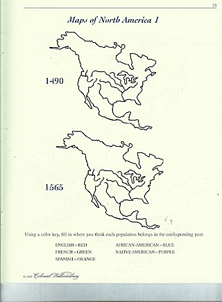
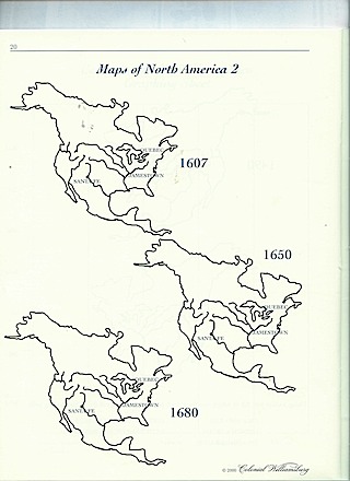
Using information from the graphs, the students will shade areas of various time period maps of North America to indicate where each group lived/claimed.
Each group’s area should be shaded using the color-coding listed on the maps--
English-Red; French-Green; Spanish-Orange; African-American-Blue; Native American-Purple.
The 5 Maps from the Mission to America for this activity are included in the lesson file.
Analysis: Once the maps are completed, the members should compare the maps and write a summary of the changes they see in the groups’ claim/area –the declines, increases, where the changes occurred, etc. The group should use the maps to make inferences about the impact each group’s exploration and presence made on the area, the neighboring people, and the economy. The small group should generate at least two inferences per map. (Wait time can be used perusing information with the Mapping CD-ROM)
Large Group-The inferences/conclusions should be shared with the whole class. Discussion should then center on the effects of colonization on the groups and the land.
Questions to consider--How did each group’s motives and values about exploration and land use influence their claims, trade, and treatment of other people? How would that affect their maps and perceived boundaries?
Extension activity: Students will create a summary of the perspective
of the effects of exploration by completing one of the following products:
-listing the pros and cons of exploration in a graphic organizer including images from the time period to illustrate conclusions (websites and CD-ROM will provide examples for use)
-creating a series of lines of dialogue between a Native American and one of the European explorers about the effects of exploration on their culture, land and their lives;
-create a song written from the perspective of a Native American about the changes in the lives the result of exploration AND alternate verses from the perspective of an explorer from Spain, France or England giving their perspective as well
-drawing a detailed map of a specified area from the perspective of a Native American who wants to keep the land showing how vital it is to your tribe, or French explorer, Spanish explorer, or English explorer that reflects their group’s values about the land and use it as a way to convince their countrymen to settle in the area (This idea came from an activity in the Degrees of Latitude pamphlet-page 20- Colonial Williamsburg 2004 publication).
Or the student may propose an idea (get approval of the instructor) of their own that would demonstrate their understanding of the impact of exploration prior to completion.
Day 3-The created products
should be shared with the large group with discussion and follow-up questions.
Review the pros and cons of exploration and extend that into a discussion of
exploration today—the impact of exploration and contact with isolated cultures
as well as the globalization of trade and culture that exists today.
The novel, The Light in the Forest, can be
used to help illustrate the difference of perspectives between White settlers
and Native Americans. I’ve read it to classes and have had students read it and
hold discussions about the conflict the main character feels as he must make
choices.
Worksheets and materials mentioned in this lesson are included in this file.

@ COPYRIGHT, The Center for Learning. Used with permission.
US History-Book 1
Beginnings to 1876 -page 9- Copyright
1997
Note: This map can be used for review and background
information to review where cultural groups existed prior to exploration.
Students should review the ways of life, housing, food sources etc. of each
cultural area prior to completing
the activities in this lesson.


